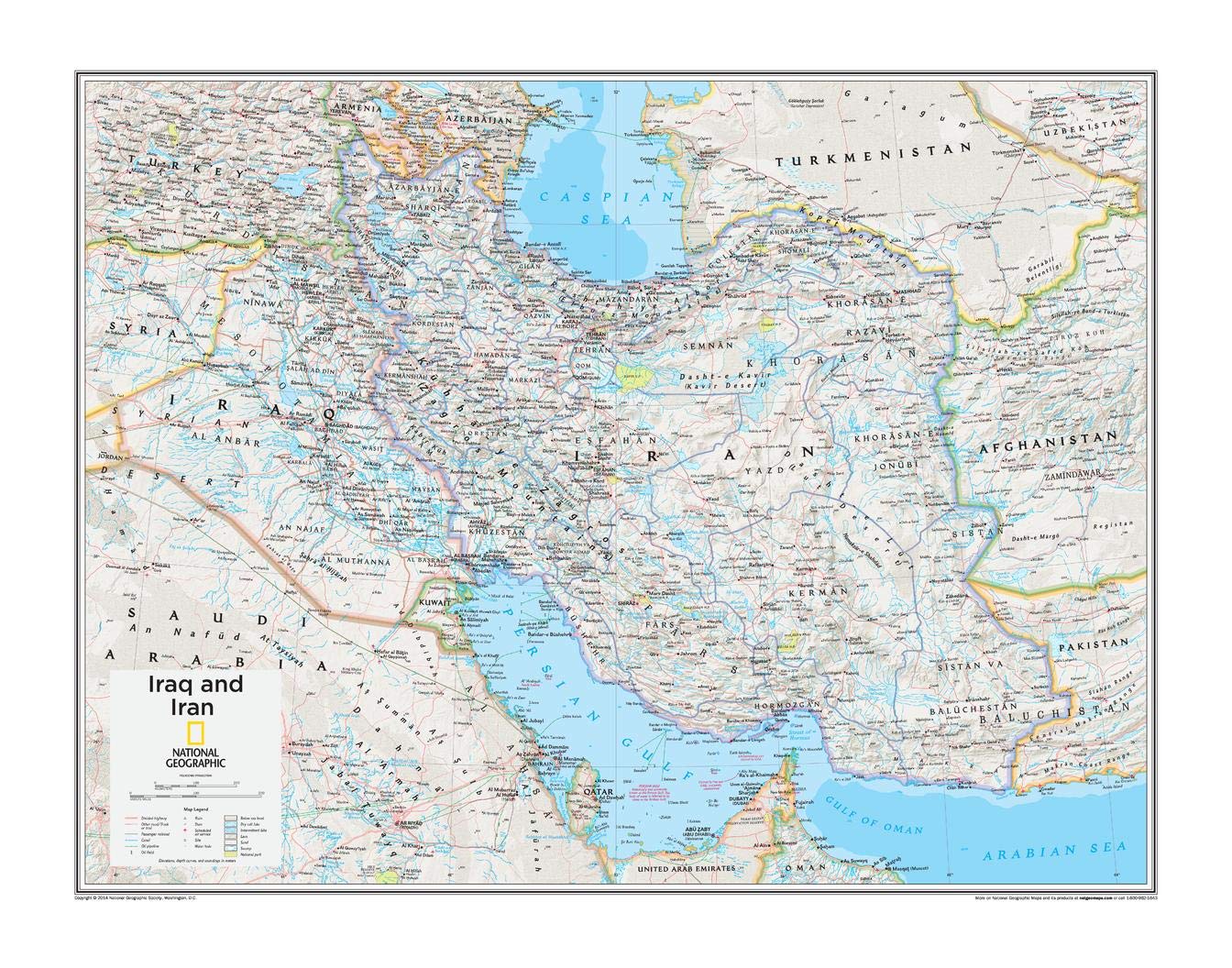
National Geographic: Iraq and Iran Wall Map - 28 x 22 inches - Paper Rolled
$37.99
| Brand | National Geographic |
| Merchant | Amazon |
| Category | Office Supplies |
| Availability | In Stock |
| SKU | B07YN71S6N |
| Age Group | ADULT |
| Condition | NEW |
| Gender | UNISEX |
| Material | Paper |
| Google Product Category | Office Supplies |
| Product Type | Office Products > Office & School Supplies > Education & Crafts > Geography Materials > Maps |
About this item
National Geographic: Iraq and Iran Wall Map - 28 x 22 inches - Paper Rolled
BUILD GLOBAL AWARENESS: Perfect for the classroom! This map is the perfect tool to help students truly conceptualize the world geographically. CLASSIC MAP FOR OFFICE OR HOME: Perfect size for a gallery wall collection - the rich colours will add a pop to any wall! QUALITY PRINT: Printed on thick paper suitable for display on your home, school or office wall. ICONIC CARTOGRAPHY: National Geographic's maps are the standard others are measured against. You can count on this product having the highest quality content and display in the industry. TRUSTED CONTENT: National Geographic prides itself on the calibre and rigour of its editorial process so that you can count on having accurate information on every map
This Iraq and Iran map of physical and political features can fit in any space. Showcasing the region in stunning detail with state-of-the-art cartographic techniques delivering accuracy and exceptional quality, the innovative and engaging design makes the content easily accessible and user-friendly.
Ideal for classrooms with an emphasis on teaching geography or environmental themes. The inclusion of physical features gives your students a genuine feel for how our world appears.
This map uses a bright, easy to read color palette featuring blue oceans and stunning shaded relief that has been featured on National Geographic wall maps for over 75 years. It is drawn in the Polyconic projection, where the parallels are all non-concentric circular arcs except for the equator, which is straight.
National Geographic's maps are the standard by which all other reference maps are measured. The maps are meticulously researched and adhere to National Geographic's convention of making independent, apolitical decisions based on extensive research using multiple authoritative sources.
This map is found in National Geographic's 10th Edition World Atlas, published to mark the 100th anniversary of National Geographic Cartography, and is now available as a stand alone product.
Printed on high quality thick paper strong enough for display on your wall.
Your map is rolled and packaged in a sturdy tube to protect it during shipment.
| Brand | National Geographic |
| Merchant | Amazon |
| Category | Office Supplies |
| Availability | In Stock |
| SKU | B07YN71S6N |
| Age Group | ADULT |
| Condition | NEW |
| Gender | UNISEX |
| Material | Paper |
| Google Product Category | Office Supplies |
| Product Type | Office Products > Office & School Supplies > Education & Crafts > Geography Materials > Maps |
Similar Products


Compare with similar items
JAM PAPER Stay-Flat Photo Mailer Envelop... |

Personalized Name Labels for Kids (180),... |

Hartford Ventilation Floor Register 4” x... |

multiwins No Soliciting Sign For House, ... |
|
|---|---|---|---|---|
| Price | $19.79 | $13.49 | $13.95 | $9.99 |
| Brand | JAM Paper | MELU Kids | Hartford Ventilation | multiwins |
| Merchant | Amazon | Amazon | Amazon | Amazon |
| Availability | In Stock | In Stock | In Stock | In Stock |